Categories
Stories

Associations between local land use/land cover and place-based landscape service patterns in rural Tanzania

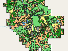
We are excited to share new land use data from Tanzania that have been used to prevent misuse of natural resources. This unique data has developed with a new geospatial mapping method for local level land use planning in Tanzania. Land use data has a significant impact for the community by their involvement in the […]

Categories
Stories

Temperature observations from Turku in August 2006 and 2007

We are glad to announce that part of the TURCLIM data is now available in Excel format. The data consist of the TURCLIM observation points, and their x- and y-coordinates. TURCLIM data include the average temperatures of the observation points that have been measured in August 2006 and 2007. For example land use and elevation […]