We are excited to share new land use data from Tanzania that have been used to prevent misuse of natural resources. This unique data has developed with a new geospatial mapping method for local level land use planning in Tanzania. Land use data has a significant impact for the community by their involvement in the data generation and for the planning process. It is a great example of how collaboration with practitioners working at the grassroot level can create new practises leading to new development. The aim of the data is to discover a relationship between land use/land cover (LULC) patterns and ecosystem services in three Tanzanian rural villages.
The data provide a great opportunity to study how multifunctional and fragmented landscapes in the Global South come to yield multiple human benefits. It is meaningful to understand how the coupled natural and cultural systems interact together and evolve over time, and how the physical environment transforms to human benefits. Such knowledge is especially vital in the rural South, because livelihoods of local communities are depending on the surrounding village landscape.
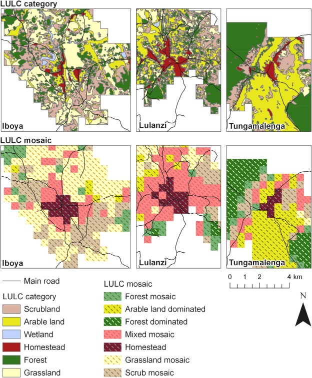
Photo 1. LUCL maps with 6 categories and the characterization of LUCL pattern with 7 LUCL mosaics in the three villages
The data consist of the LULC categories and mosaic maps (photo 1), which have been created to describe the physical landscapes and the ways people use the land. The LULC categories are scrubland, arable land, wetland, homestead, forest and grassland, which were designed based on the field experience. LUCL mosaics was statistically defined by the hierarchical cluster analysis, and . characterized the LUCL patterns in each grid cell.
Table 1. Place-specific landscape services and description of the provisionings and one cultural landscape service indicator
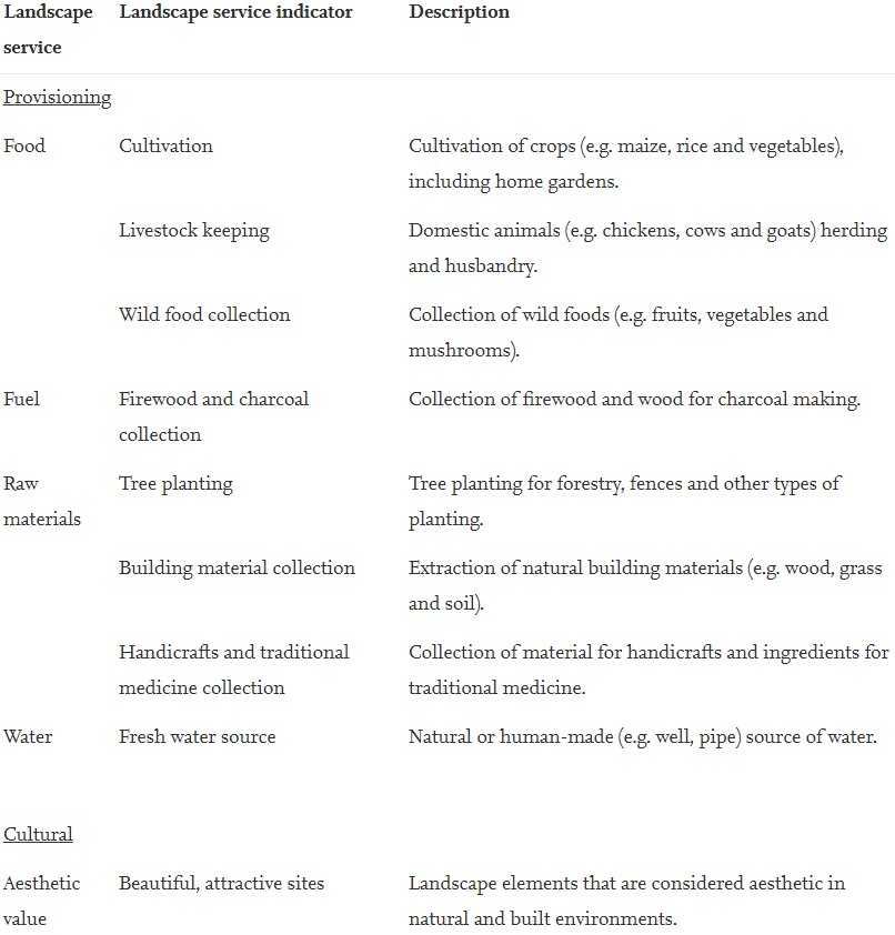
The local LULC patterns were associated with the place-based landscape service indicators (table 1), which were collected in a participatory mapping campaign from February to March 2016. The community members captured the tangible material (provisioning) and non-material (cultural) services that locals obtain from their everyday landscape. Each service has been addressed through a landscape service indicator. For example the provision service of food includes livestock keeping, cultivation, and wild food collection. An area where the service is utilized is indicated through the mapped points. All mapped points were transferred to a digital format and spatially joined to the 500 m grid for calculation of landscape service metrics.
Joni Koskikala is PhD student at the University of Turku, Department of Geography and Geology. He’s the corresponding author regarding this data and was also interviewed for this blog post.
More detailed information about the data can be found from the article Arki et al. 2020. Associations between local land use/land cover and place-based landscape service patterns in rural Tanzania: https://doi.org/10.1016/j.ecoser.2019.101056
What is SUSLAND?
- Datacollection and the article were part of a development research project called SUSLAND (Sustainability, scale relations and structure-function-benefit chains in the landscape systems of the Tanzanian Southern Highlands).